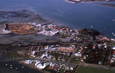
Slide, Aerial View, Tauranga Harbour
Maker
Robert Gale
Production date
26 Apr 1964
Current rights
© In copyright
See full details
Object detail
Description
A colour slide showing an aerial view of Tauranga harbour, an industrial area and houses. The location has been identified as Sulphur Point. Top left corner shows an area of the harbour that is being reclaimed. The Mission Cemetery and The Elms are visible on the right side of the image. Recorded by the photographer as ‘Sulphur Point’.
The Tauranga Heritage Collection has more than 2000 photographic slides taken by Robert Gale. Robert and his family moved to Tauranga in the early 1960s and he taught at Merivale School until retirement. Robert was a member of the Tauranga Photographic Society for many years. We ask that you publish an acknowledgement, or 'attribution', to Robert Gale when using this image.
The Tauranga Heritage Collection has more than 2000 photographic slides taken by Robert Gale. Robert and his family moved to Tauranga in the early 1960s and he taught at Merivale School until retirement. Robert was a member of the Tauranga Photographic Society for many years. We ask that you publish an acknowledgement, or 'attribution', to Robert Gale when using this image.
Maker
Robert Gale
Production date
26 Apr 1964
Production place
Tauranga, Bay of Plenty, New Zealand
Measurements
50mm (width), 50mm (height)
Credit line
Gifted by the Gale family and Alf Rendell
Accession number
0005/20/640
Current rights

